Brought to you by Howard Sheckter
Current Storm System Off Shore Has Plenty of Fuel….However Not Much Spark! Nevertheless Mammoth Mt will get a nice Freshing of its Surface Mid week…..The Following Weekend Will be Fair…
Monday March 18, 2013
Tuesday Evening….
-AO and -NAO still is expected to break down by month end….
Technically, we should have a pattern change going into the end of the month…..
Say good-bye to Winter….Spring arrives at 4:02AM Wednesday….
What do you get with a juiced up atmosphere with no spark? A wasted opportunity that is for sure….
The Spark being referred to is dynamics. Dynamics creates lift. It takes lift in the atmosphere to squeeze the sponge. Where is the lift? Looking NW it is in the Gulf of AK. But the timing is off. The Moisture will get in here Tuesday and Tuesday night before the colder system with its lift does on Wednesday. The basic lift involved will be orographics. I do not expect more than a trace to an inch or two in town Wednesday. Snow level will be 7500 ft Wednesday.
Amounts will range from 6 inches to 10 inches on Mammoth Mt. Snow to Water Ratio’s ave 7:1 QPF from mainly orographics, .5 to 1.0
Of course this is not the whole story. There are more fundamental issues that are still causing the head winds, “figuratively speaking” and the persistence of the dry pattern we have been dealing with since the beginning of year. In short, the (-AO and -NAO Combo) have done a job on us this winter, and we are/will continue to feel its effects in a negative way until that system breaks down! Look at the standard deviations of normal in the -AO…almost off the charts!!!!!!! It is no wonder why the mid west and the east have had one of the snowiest winters in the last 100 years….
-AO: http://www.cpc.ncep.noaa.gov/products/precip/CWlink/daily_ao_index/ao.sprd2.gif
-NAO: http://www.cpc.ncep.noaa.gov/products/precip/CWlink/pna/nao.sprd2.gif
Until the -NAO returns to at least neutral, its drought city for the central and southern west coast. Now this pattern was some what predictable by knowing that the QBO was heading toward neutral during the coldest part of the year. Remember that when the QBO index is in transition, -10 to +10 it points to a greater degree of certainty of the formation of the -AO/-NAO Combo) during Jan, Feb, March. Calculated at PSD (from the zonal average of the 30mb zonal wind at the equator), as computed from the NCEP/NCAR Reanalysis). SEE: http://www.esrl.noaa.gov/psd/data/correlation/qbo.data
Long Range:
From What the Dweebs see….That system will stay intact through the end of March and will slowly break down in April which may lead to a wet April into early May.
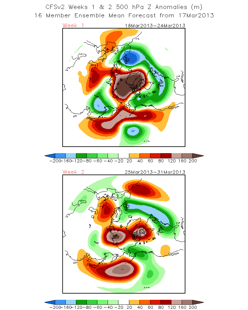
See CFS v2 500 hPa z For weeks 1 and 2 http://www.cpc.ncep.noaa.gov/products/people/sweaver/cfs_fcst/images1/wk1.wk2_20130317.z500.gif
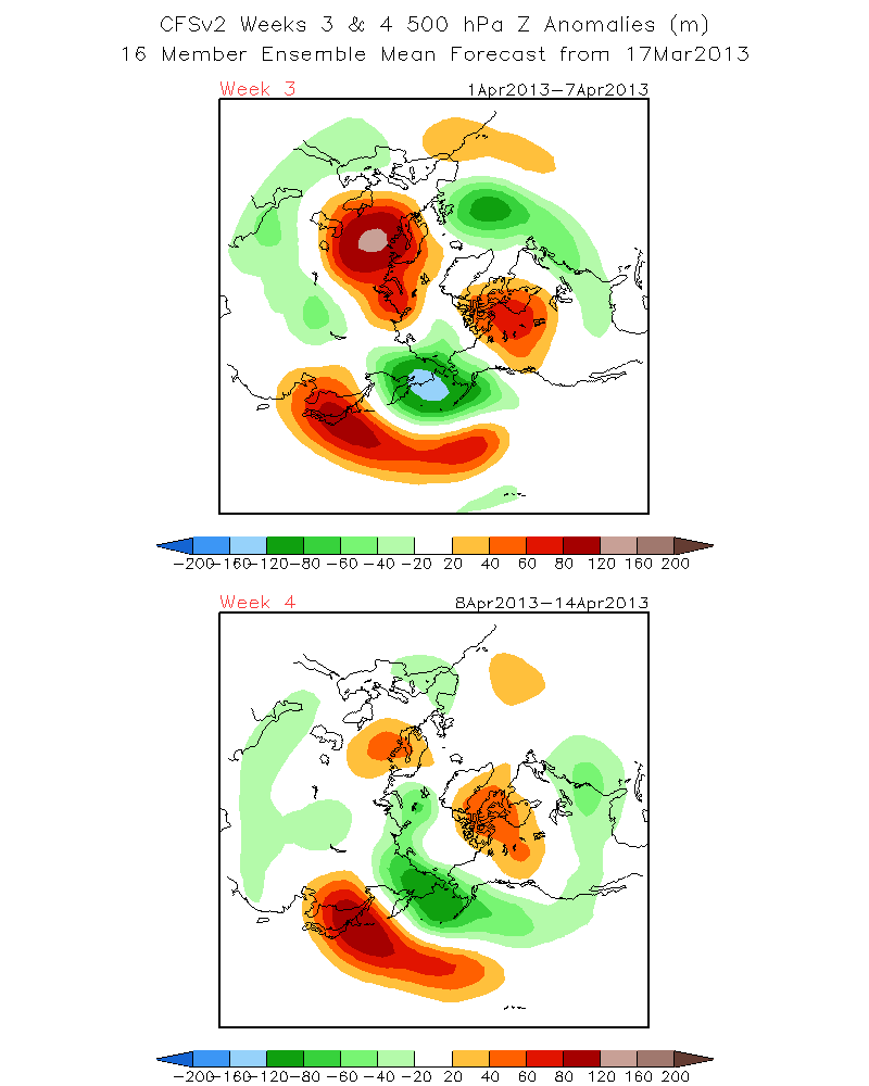
Weeks 3 and 4 http://www.cpc.ncep.noaa.gov/products/people/sweaver/cfs_fcst/images1/wk3.wk4_20130317.z500.gif
As you can see, the Block really breaks down in April….
Dr Howard and the Dweebs………………………………………..:-)


