Brought to you by Howard Sheckter
Moisture Fetch now lifting north with Some Sunshine expected today….Warming trend to kick into high gear Wednesday with upper 80s expected by Sunday in Mammoth…Heat wave may last 7 to 10 days…..High based thunderstorms a good possibility next week….
Tuesday June 25, 2013
Tuesday AM:
Moisture band still effecting the high country of the Central Sierra. Light rain fell Monday with amounts .12 to .15 recorded from RAWS sites around town. Checking SFO Radar, most of the shower activity is Sonora Pass north at the moment. Although there are still some showers to the west of Mammoth and out over the Valley. The latest guidance shows the upper jet along the CA/OR border today…then lifting NE toward Washington state and Canada Wednesday into Thursday.
Strong rapid height rises are expected at 500MB over the far west next 24 hours including Mono County. This mornings 12Z WRF shows the 588DM height line pushing north of Mammoth tomorrow morning about 8:00am. So although high temperatures will again be difficult to forecast today because of Cloud Cover, with the projected height rises, the moisture band should gradually move north today as well. So some sunshine is possible today and thus high temps will likely get into the 60s this afternoon.
Outlook:
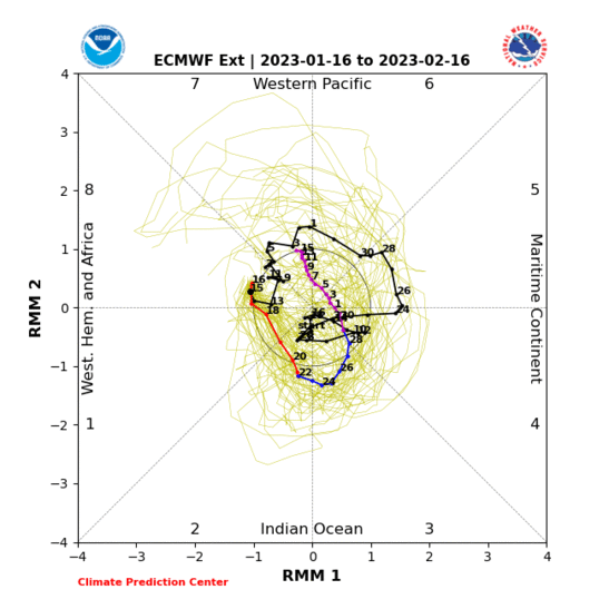
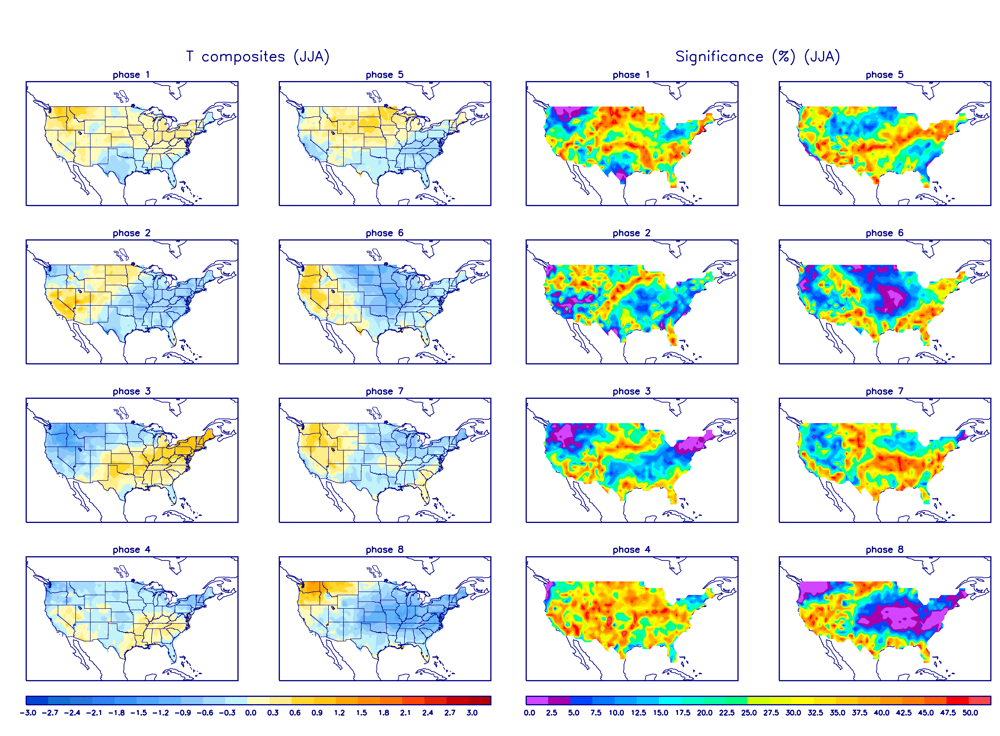
The Dweebs did some MJO work and noted that for the months of June, July and August, when the MJO projects into the Wheeler Phase Space 1 and 2, hot weather can be expected for California. I think that the ECMWF Ensembles have a better handle on this, as it holds on to the heat longer. If the EMON is correct in its projection, we can expect very warm weather to develop as progged by both the GFS and EC beginning this Thursday. However, the EC 00z Tuesday continues the anomalous heat longer through the 360-Hours. The GFS on the other hand weakens the upper ridge too quickly after the 3rd of July. There is better support for the upper ridge to remain longer as the MJO remains in phase space 2 through about the 8th or 9th of July. See: http://www.cpc.ncep.noaa.gov/products/precip/CWlink/MJO/CLIVAR/EMON_phase_51m_full.gif
Thereafter the EMON tracks the MJO into phase space 3 which is cooler then normal for California. See: http://www.cpc.ncep.noaa.gov/products/precip/CWlink/MJO/Composites/Temperature/JJA/combined_image.png
Thus the GFS may be much too quick in breaking down the upper ridge over the west. The EMON is suggesting that the heat will not break until about the 9th of July! For our high country, should this heat wave develop as planned, no doubt that eventually, air mass modification will give Mammoth a nice break with afternoon and evening thunderstorms while the Owens Valley Bakes into the 2nd week of July.
With the upper high again forecasted to be closer to California, record or near records are possible. Here are your record highs for the Owens Valley next week.
Sunday the 30th, 108; Monday 105; Tuesday 105; Wednesday 107; Thursday 107; Friday 108.
Dr Howard and the Dweebs……………………………:-)


