Brought to you by Howard Sheckter
Major Sierra Storm headed for the Sierra….Winter Storm Watch for Mono County and the Owens Valley Tuesday Night through Thursday Night…..Cutting through the hype of the Atmospheric River Forecast……..
Sunday January 24, 2021
New update from CRFC at 12:21 PM shows about a 15% reduction in the QPF over this mornings output.
Huntington Lake now 10.83 in
Yosemite now 8.45 in
So as an average 9.64 west of Mammoth Mt
Most of which will fall by Friday AM…. (8 to 10 feet) at 12:1 above 10,000 feet by Friday AM
3 to 4 feet in town….
Will update again Tuesday….
_____________________________________________________________________________________________________________________________________________________________________________________________________________________________
1-25-2021
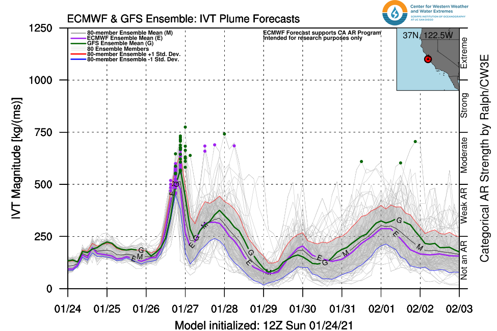
Keeping up with the AR information, I have done some brief research to share with you all….. This concerns the intensity and location of the AR as well as a few differences in the models; GFS and ECMWF. It appears that the ECMWF has two ARs of moderate intensity and the GFS has mainly one moderate to borderline strong one, as depicted by the ITV information. In the clickable pics below, you can see that there is definitely two ARs with the EURO for both Wednesday, which is the primary and Thursday the secondary. Also, another weaker one, possibly setting up for early next week.
I checked the CRFC QPF for the areas both north and south of the San Joaquin River and the Bullseye for total QPF seems to be just south for the period between today through Friday. Looking for between 9.5 and 11 inches of QPF. That may mean as much as 9 to 10 feet of snow over the summit at 12:1 as the storm is pretty cold.
It should be noted that many AR’s are very warm and wet like the one in early January1997 and again in February 1986. This one is cold…..Which is what we need, not only for our snowpack, but also for the concerns of the San Joaquin drainage. As, after last Summers Creek Fire, with that much rain falling in that area, it may cause problems for the San Joaquin drainage basins water shed, and issues down stream into Millerton Lake.
See the ITV for Both GFS and Composite of GFS and ECMWF the next 7 days near our Lat/Long.

___________________________________________________________________________________________________________________________________________________________________________________.________________________________________________
2:30PM Update
FROM WSFO Vegas
Winter Storm Watch in Effect for the Owens Valley Tuesday Evening through Late Thursday Night into Friday. Heavy Snow with snowfall accumulations 5 to 8 inches on the valley floor along Highway 395 with over a foot possible above 4500 feet. Travel could be very difficult to impossible, especially along Highway 395, State Route 168 through Westgard Pass, Highway 190 and Highway 136.
Extended Outlook For Mono County;
ECMWF has come in with 12 inches water EQ, just west of the Mammoth Sierra Crest, between today and the 3rd of Feb.
Bullseye is over Central Sierra now which makes better sense as that is where the heart of the AR is…
___________________________________________________________________________________________________________________________________________________________
From This Morning…..
In the link below, is the Global Forecast Systems projection of the “AR” that is headed for California. As you will see, the upcoming AR is not a major Atmospheric River (AR), but a moderate one, mainly for this upcoming Wednesday with a weak extension expected for Thursday. There are no “AR’s” projected for next Friday and Saturday next week, however, “AR” moisture is progged to return the following Sunday into Monday in the “weak range” category. Atmospheric rivers are categorized by a unit of measurement called Integrated Water Vapor Transport (IVT). IVT takes into account both the amount of water vapor in the system and the wind that moves it around, making it flow like a, well, giant river in the atmosphere.
In the link below, is a forecast for a “Moderate” AR for the upcoming Wednesday. Its IVT is about 700 at its peak near our latitude. Major ARs have IVT’s above 1000. At our latitude not shown, the ITV does reach briefly 750 Wednesday AM. So that is borderline strong.
Of Note, both GFS and ECMWF have main Bullseye of precip over the Northern Sierra though February 3rd. However, the main AR is focused over the central sierra, so there is a bit of disconnect. Both Global models give the Sierra on the west side of the crest, about 10 inches of water. The snow to water ratios because of the cold temps will be higher. Instead of the average 8:1 to 10:1, were probably looking at 12:1 or even a bit greater. At 12:1, 10 inches of water is about 10 feet of snow as it falls, along the crest.
This is the period ending the morning February 3rd, 2021.
_______________________________________________________________________________________________________________________________________________________________________
Scenario …..
A Light to moderate storm is expected Sunday night into Monday night. 6 to 12 inches is possible over the upper elevations of Mammoth Mt. 3 to 5 inches possible in town.
Snow showers are possible Tuesday….
The storm system that develops Tuesday night contains the moderate AR which develops early Wednesday AM. According to the progs, the system will be such a successful precip producer because; as the lead Trof digs down the west coast, an upstream short wave digs the main trof southwestward, with the result forcing the main trof’s baroclinic zone to stall over Central California. This is a prefect progged scenario for a major snowfall producing storm for Mammoth.
As the system becomes positive tilt, AR moisture is entrained and forced NE’ward from the southwest, south of the main WX front. The track of the secondary short wave that digs the system SW, is due to changes in the upstream ridge which is both highly amplified, but at the same time, is forced to retrograde, allowing changes in the structure of the off shore trof affecting the west coast. This is a solid two day storm that will linger into Friday AM. The storm has the capability to dump 6 to 7 feet on Mammoth Mountain between Tuesday night and Friday Morning.
The last in the series will move in Sunday the 31st, and last into Tuesday AM. Although there is not as much confidence in this system because of its distance in time, It appears it too will have at least a weak atmospheric river Sunday night into Monday, the 1st of February and yes, may drop several feet of snow, based upon pattern recognition.
After February 3rd, the jet is expected to shift north with the focus back up into the pacific NW. We can still get weather systems over the sierra, however, they will be more of the showery nature….
As far as sensible weather, it is going to stay cold with lows in the single digits and teens early in the period with 20s after mid-week. Highs in Mammoth will be in the 20s early next week with highs in the low to mid 30s during the second half of next week.
For travelers; road closures are possible Wednesday and Thursday on highway 395, as strong winds and blizzard conditions are expected at times. For those that may be thinking about spending the night in their cars or campers to ski the following days, your are risking your life due to hypothermia.
Dr Howard and the Dweebs………..:-)


