Brought to you by Howard Sheckter
Platinum Powder Alert for Sunday AM…..with 1 to 2 feet of Platinum Powder possible….Additional Storm totals of 2 to 5 feet by Tuesday AM….Turning Colder….
Friday December 24, 2021
Oops!
Not sure what’s happened with the pattern out over the pacific. It looks like the blocking high that would not die….
canceling the big change in the pattern for the time being…..concerned where the pattern is going…..,
Sunday the 26th,
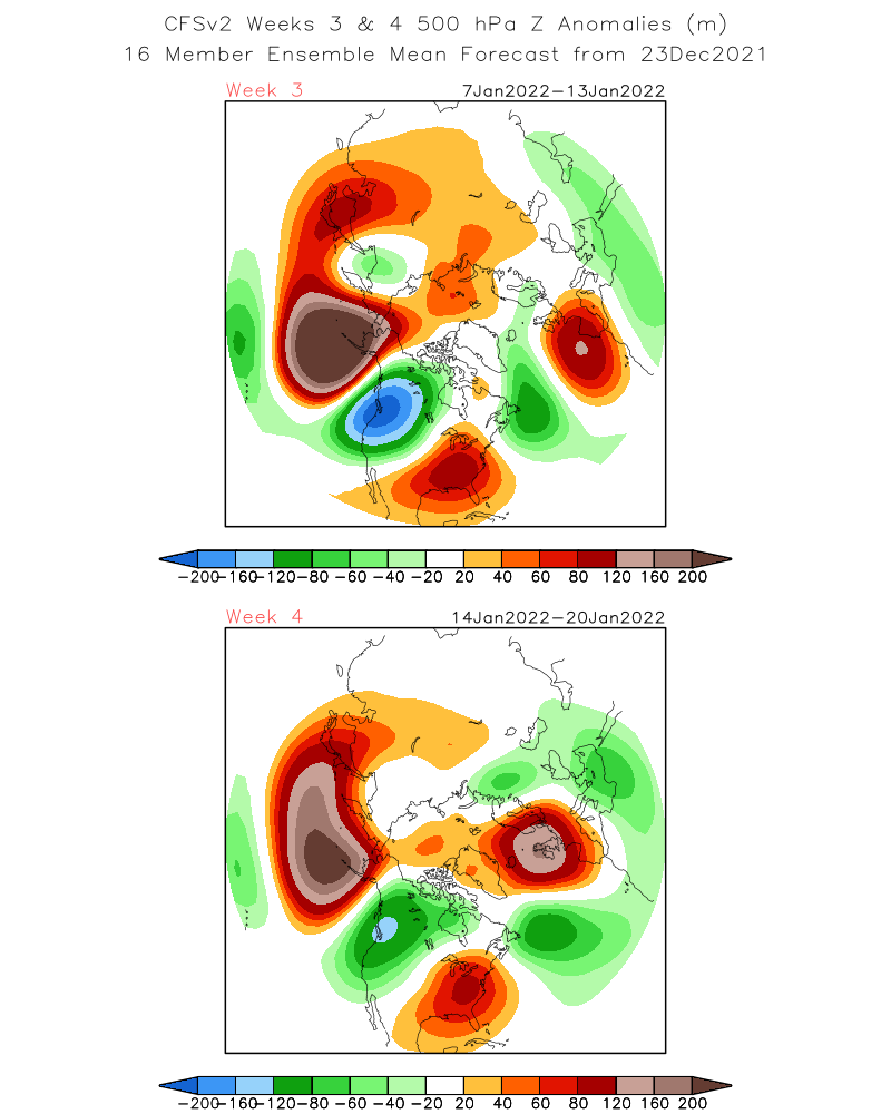
Latest update shows cold Trof to being additional amounts of snowfall through New Years…..However, big change in the pacific pattern will break down the central pacific ridge and thus will bring an end to the current siege of storms, “during the first week of January”….By the weekend of the 8th, the Dweebs expect an upper ridge to dominate the far west for a while. Note…….There may be one more storm early the first week of January.
Dr Howard and the Dweebs……………………:-)
________________________________________________________________________________________________________________________________________________________________________
AR with many areas in the high country receiving 6 inches + of Water past 3 days…. The AR ended up in the Low level 3 range and has been extremely beneficial to California Water Supply. The snow level went as high as 8500 feet Wednesday Afternoon and was down to 5500 at 6:00AM Thursday AM. Our storms will bring all snow to resort levels through the end of the year now. There is a Platinum Powder Alert for Sunday AM for the possibility of some 1 to 2 feet of cold dry powder on Mammoth Mtn. 7 day QPF suggests between 7 and 9 inches of water additional through New Years. 6 to 8 more feet of snowfall by years end from today.
For those that are interested, The upper hemispheric pattern is being forced by the MJO in Phase 7. It been static there and strong. It has strongly contributed to the mean position of the blocking ridge between the GOA and the Bering Sea.
- SEE: https://www.wpc.ncep.noaa.gov/medr/mrfmeans.shtml
- The question remains where does the MJO from here in the weeks to come. The CFS suggests phase 8. That location often highlights a Closed High over or near the Bering Sea.
See: https://www.cpc.ncep.noaa.gov/products/precip/CWlink/MJO/foregfs.shtml
AND and another AR above week 3…….. 
Again….The big question remains….Where do we go from here? There is going to be a major transition in the pattern during the 1st week of January. Pattern recognition suggests Phase 8 by the Climate forecast System which can be very wet for CA. We’ll see…..
Merry Christmas and Happy Holidays to all from Dr Howard and the Dweebs……………………..:-)


