Brought to you by Howard Sheckter
Beautiful Day Friday with very light snow Saturday….Massive Storm with 1-2 punch beginning Sunday with strong AR Monday…..Snow Levels tricky!!
Friday January 6, 2023
1/7/2023
10:40AM
Quick update:
No change in the forecast for today. Flat light conditions, no significant snow today. Winds picking up over the upper elevations.
Next wave comes in tonight with light to moderate snowfall. Expect about 6 to 12 inches over the upper elevations by mid day Sunday. About 3 to 6 inches in town. Wave should be through with diminishing winds aloft early Sunday afternoon. Decent travel in the afternoon. High today 35 low 25. High on Sunday 35…
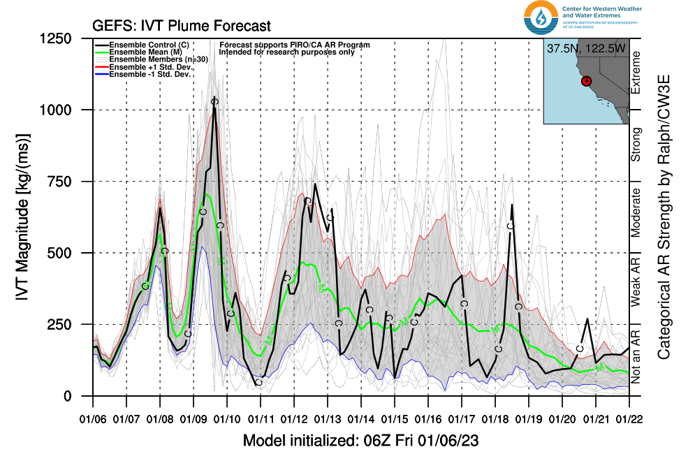
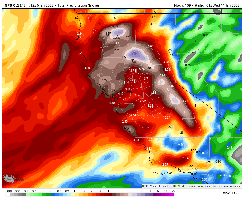
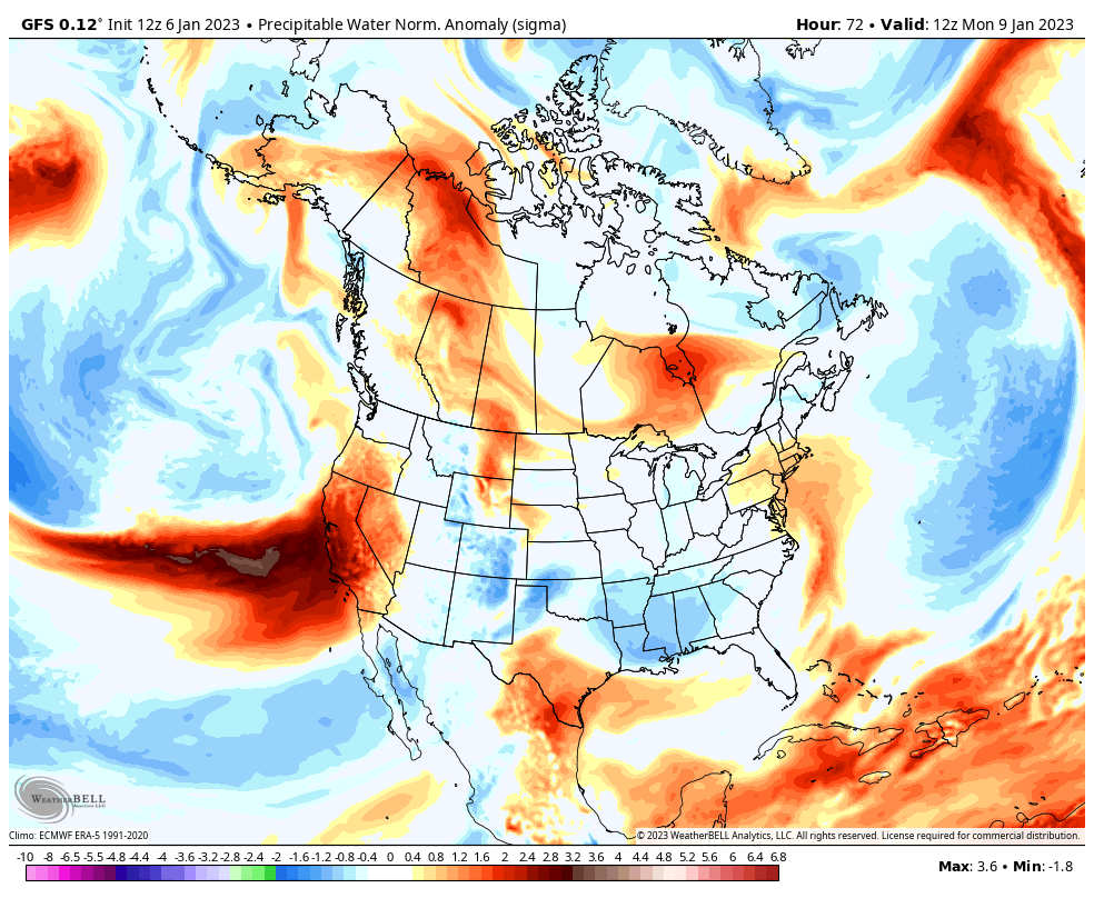
Next storm is the wet AR for Monday. Moist surge moves on shore about mid night Sunday night and increases early Monday AM. Snowfall rates increase Monday AM after midnight Sunday. I have questions in regards to the snow level Monday afternoon as the freezing level goes up to 8000 to 8500 feet near Yosemite. The Snow level forecasted by NWS is at 7000 feet. Possibly the AR does not get that saturated air this far east? Will update snow levels tomorrow afternoon for Monday. FYI; California Nevada Forecast Center (CNFRC) is forecasting shows that during the AR and including the cooler part of the storm Tuesday, Yosemite gets 6.62 inches of water and Huntington Lake gets 7.15 inches of water. That’s about that 4 to 5 foot storm for the upper elevations for that storm. Add on the Sunday system for about a foot…..5 to 6 more feet!
Outlook:
For the outdoor enthusiasts,
It is estimated that a break in the weather may occur mid-day Wednesday through possibly Friday with Sun, periods of wind and mainly periods of very light snowfall.
Longer Range; (Outlook, highly subject to change)
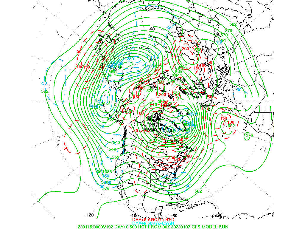
The pattern is beginning to change a bit later next week in that pressures aloft are increasing over the Rockies. This will slow the advance of weather systems later next week as well as weaken a few including the Friday night system into Saturday night. 14th and 15th.
Beyond that weekend the storm track is shifting more to the north, and so snowfall will be less with each storm, beginning around the 18th of January. Again, this is subject to change… (See Day 8 Means below) See Split Flow Day 8.
Dr Howard and the Dweebs…………………….:-)
__________________________________________________________________________________________________________________________________________________________________________________________________________________
Beautiful Blue Bird Day! Weak ridge of high pressure that moved in last night will be with us today and ensure a wonder day for Skiing and Boarding. Mammoth Mt now Boasts 11 to 15 foot base. 37 inches of new fell over the past 3 days.
Weather pattern continues active with a small system for Saturday, bringing an inch or two of snow and moderate wind. Winter storm warning are hoisted beginning Saturday at 4:00AM mainly for wind. The tempo for snowfall will increase Saturday night and especially Sunday as a moderate storm moves into the area for Sunday. The NEXT STORM is a powerhouse. It contains a strong atmospheric river (see Graphic’s below), beginning Monday morning through Monday night. Copious amounts of precipitation are expected to fall with the snow level rising to 8000 feet Monday. 3 day Snowfall amounts will be in the 4 to 7 foot range over the higher elevations Sunday through Wednesday AM. There looks to be a break Wednesday into Thursday. Another storm is possible late Thursday through Friday.
As a note, there are several surface lows rotating counter clockwise around the mother low early next week. However, there are two surface lows that make it onshore early Monday Evening and another later Tuesday AM of significance!