Brought to you by Howard Sheckter
Strong Wind Chills of yesterday have abated while warming today will push highs into the mid 30s!….This weekend will be Breezy or Windy with the chance of Snow…..
Tuesday January 24, 2023
1/25/2023
Wednesday AM update;
Model runs still look good but not as wet with the Sunday-Monday system. About .75 of an inch of QPF looks good for the Sierra Crest. This means a good foot of snow at the higher elevations as snow to water ratios by Monday afternoon, 15:1 or better. Modified Arctic Air is still being pulled SW from Central Canada for a very cold early next week. Mondays highs could be in the teens in town, with below zero temps Monday night. This is a classic response to La Nina which has strengthened a bit in the past week or so.
Longer Range:
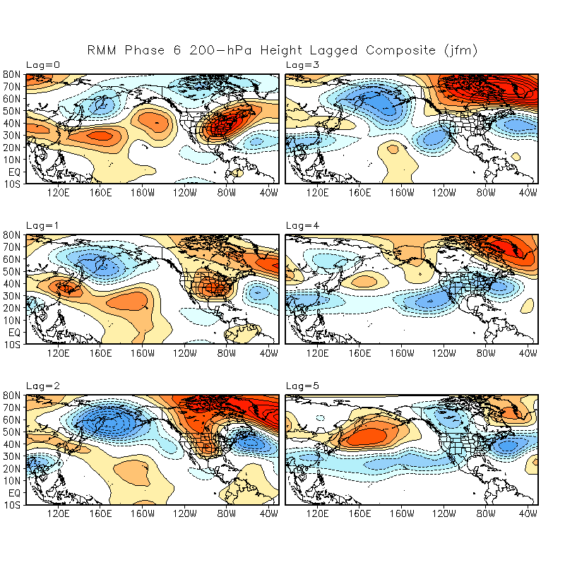
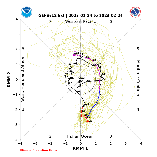
I have posted the MJO and Phase Space RMM for your perusal.
It suggests that an extended dry period is ahead of us through the middle of February. If the GEFSv12 Extended verifies, Phases 4, 5 through mid 6 are pretty dry for us. See the lag graphic and RMM chart. Each Lag is a period of 5 days. It suggests that the Pacific does not open up until the 3rd week of February into March….If the MJO remains strong, that would be our next real wet period. With that said, this is subject to change if the MJO weakens.
SEE Graphics Below:
:
_______________________________________________________________________________________________________________________________________________________________________________
Today is Tuesday and the Global Models seem to coming together with a rather cold pattern the end of this weekend into Tuesday. The upper ridge in the Gulf of Alaska is being amplified by a “Super Bomb” spinning up off the coast of Japan this morning. and another few others following on its heals. WOW! The cold upper Vortex associated with these surface systems has a center of 489MB just crossing into the Sea of Okhostsk. There is another in back of it, headed for the Aleutians. Through the process, a massive amount of high pressure will build down stream over the Gulf of Alaska as its punched toward the North Pole. The down stream effect, is of pulling down a lot of Arctic Air over Western Canada with even a tug of Continental Air from Hudson Bay as well. This system is in two parts with a chilly one coming through Friday Night, mainly to the NE of us. A colder one Saturday Night into through Monday night. That one shows over water trajectory and so snowfall is expected within that time period. The system Sunday into Monday will bring a good foot of Platinum Powder. All this if the new European Model runs verifies.
QPF from EURO shows possibly a foot+ of snow, 15:1 to 20:1 by Monday night. 700MB temps are expected to get down to -18C. That means highs in Mammoth about 10F-15F degrees Monday. This would be Bugaboo, Canada powder.
Note: This pattern is still a bit of time away…Stay Tuned!
Dr Howard and the Dweebs…………….:-)


