Brought to you by Howard Sheckter
Archive for December, 2011
Little Change in the Short Term W/Two more shots of cold air headed our way…..Pattern Change Beginning Christmas with Overrunning a possibility Next Week…..
Tuesday December 20, 2011
We actually had a little Frizzle last night! (Upslope). Normally that would not be mentionable in this report. However, this morning, the Dweebs would like comment that it was a nice thought from Mother Nature. Although thus far, shes been pretty Scroogy as an Ebenezer with the Snow this year.
Pattern Change:
Through Friday, no change in the pattern. We are looking for two more shots of cold Canadian Air to advect into our area. One Late Wednesday night into Thursday and the other more mild shot about on Friday. Thereafter…a significant change occurs for the west coast; one that will bring milder pacific air into Central Ca and rain back into the pacific northwest as early as the beginning of next week. Then there is the possibility that Cold and snow will return for the high country between the 3rd and 8th of January.
Here are some thoughts and then some possibilities:
1. First of all during pattern changes, models are usually playing catchup with the details of the change, so the Dweebs forecast will be fine tuned as we get into early next week.
2. A change in the pattern does not always mean precipitation.
The Change:
1. The Eastern Pacific ridge in the mean is moving to the West Coast. (Comment) (There goes the neighborhood!)
2. That will effectively cut off the cold Canadian air that has been periodically invading the far west, keeping Mammoth cooler then normal.
3. The Pacific Jet will grow stronger next week and extend across the pacific increasing moisture and storminess for the Pacific northwest and possibly Northern Ca.
4. And…….although the upper jet will remain well to our north,” Over-running precipitation is a possibility for the Northern and even Central Sierra, “with time” next week, even though 500 Heights will be over 570dm in the mean. (See day +8 centered upon 192hr GFS) http://www.hpc.ncep.noaa.gov/cpc/cpc_NHEM_f192wbg.gif
Over running occurs and is effective in our area when cold air at the surface is entrenched and a moist flow at 700mb RH associated with the upper jet to the north drags mid level moisture into our area. It can be rain or snow! One thing is for sure, whether we get precip or not, the air-mass over central and northern Ca will be a lot more milder next week, “aloft”.
5. More thoughts….
A. In that there is no blocking downstream IE -AO&-NAO….the likelihood of a persistant highly amplified upper ridge along the west coast is not likely.
B. It is too early at this time to predict over running, but it is a possibility…we’ll see by Christmas Day, if the short term and medium range moistens up.
6. Longer range:
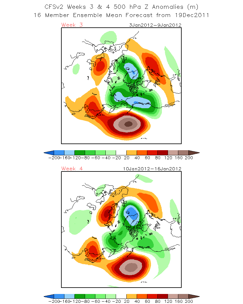
While Mild Pacific Air invades the West Coast, Frigid Air develops over Alaska and is forecasted to plunge southward over the west coast Between January 3rd and the 9th. See: the 500mb Heights forecast that period at: http://www.cpc.ncep.noaa.gov/products/people/sweaver/cfs_fcst/images1/wk3.wk4_20111219.z500.gif
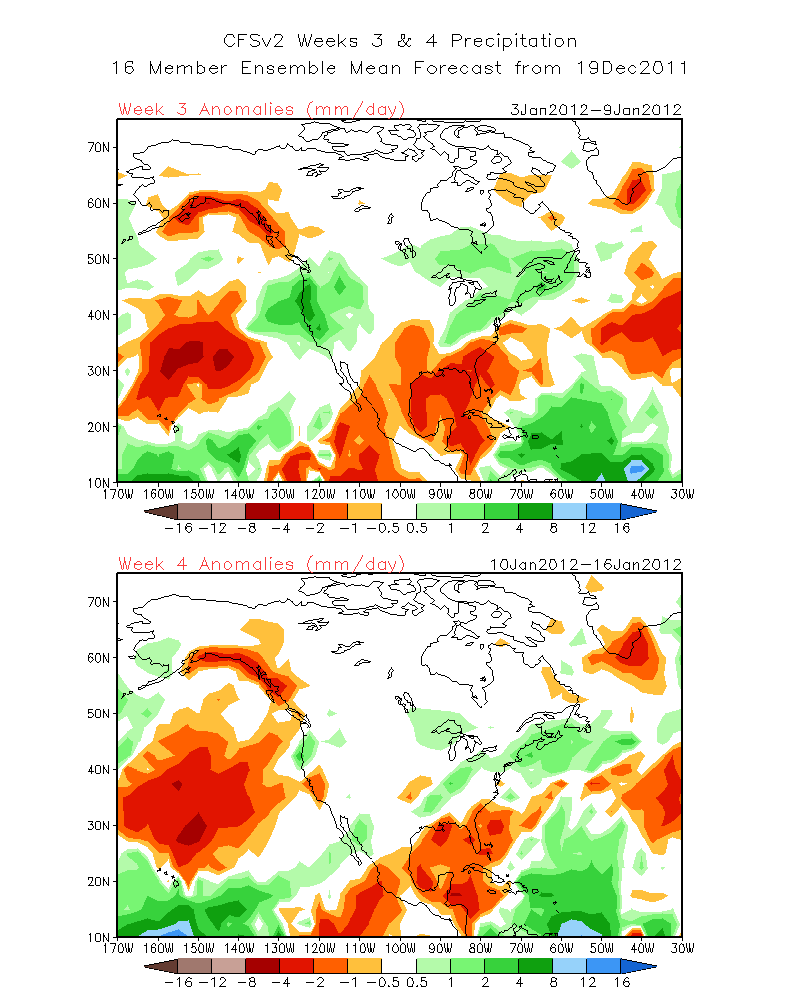
Then see the precip outlook at: http://www.cpc.ncep.noaa.gov/products/people/sweaver/cfs_fcst/images1/wk3.wk4_20111219.NA.gif
The Dweeber…………………………….:-)
————————————————-
Reference Glossary of Weather Terms
Disclaimer: I have been a hobbyist meteorologist for over 30 years here in the Mammoth area and I do this for my personal enjoyment. The National Weather Service saves lives every day . . . I do not. When making important planning decisions please use information provided by the National Weather Service as they are the most knowledgeable and accurate information source available today.


