Brought to you by Howard Sheckter
Warm Sub-Tropical Low Exiting California By Noon Today as Cool Front Moves into the Northern Sierra……Fishing Opener Looking Great!!
Thursday April 26, 2012
Friday Am update:
Storm Total of Cold Liquid 1.17 at Main Lodge with an inch or two of snow.
At the Village at Mammoth .35 inches total.
At 8000 feet there was snow/rain mix in the afternoon but no accumulation.
Elevations above 10,500 may have had 6 inches
Very windy conditions yesterday afternoon into the early evening hours with winds clocked 60 to 70 MPH in some areas of town.
Winds averaged over 100mph at the top of Ch 1 between 2:00pm and 9:00pm with a peak gust of 150mph recorded between 2:00pm and 3:00pm.
Forecast and Summery:
Upper ridge has pushed into the far Eastern Pacific this morning and will build near the west coast. However….a weak to moderate long wave trof will remain over the inter-mountain west with the affect of bringing snows to the Northern Rockies and Cold Western Canadian air to Montana and Wyoming. In that the upper flow will remain NW for the next few day over Mammoth there will continue to be breezy conditions over the sierra crest and light breezes over the lower elevations. By Tuesday…the upper flow consolidates and becomes westerly and lifts north to the pacific northwest allowing temps to warm over Eastern Ca. By Thursday…Bishop may get close to the 90 degree mark once again…. Mammoth will remain in the 60s. It will be a dry 5 to 7 days:
Longer range:
The Alaskan PV will move to the north will retrograde slowly over the next two weeks. The pattern across the pacific will slowly retrograde as well.
3 day means show an upper height anomaly just west of 140W with the upper westerly flow along 45 north and weak NW flow over Central Ca.
5 day means retrograde the upper height anomaly to the Bering Sea with the down stream westerlies into the pacific northwest well north of Ca.
By Day 8 the PV is at the dateline near the pole. Upper height anomaly weakens west of 170W, with a down stream trof in the mean between 140 and 145 west. This will allow heat to begin building throughout the desert SW with a SW flow aloft into Ca. The upper jet comes in over Washington State. This is a nice warm pattern for the eastern sierra with the usual afternoon zephyr winds. .
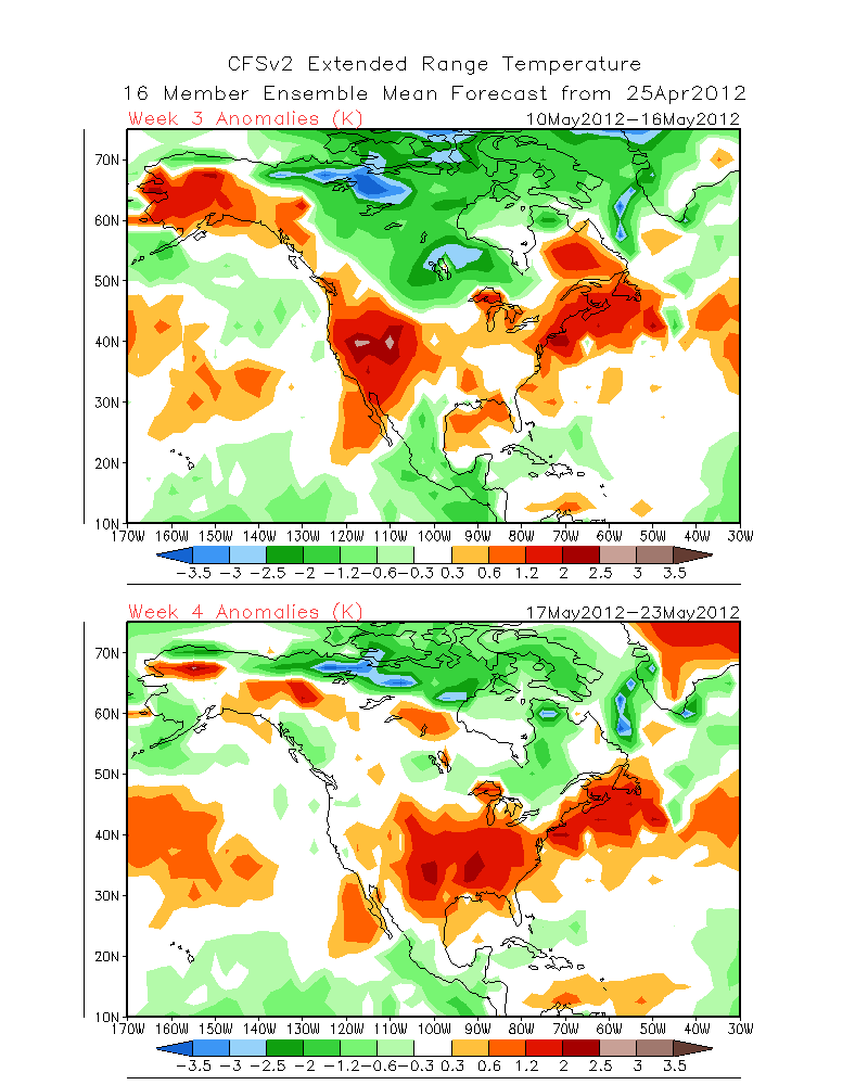
By Day +11 retrogression continues with strong height rises possible into the following week over the far west and trofing developing north of the big island of Hawaii. “The longer range may be trending toward another heat wave for Ca/NV during the second week of May over the far west…..like the one we had around the 23rd of April. Only it will be May not April.”
See the forecast for the 2nd week of May from CFV2:
Roasty Toasty!!!
http://www.cpc.ncep.noaa.gov/products/people/sweaver/cfs_fcst/images1/wk3.wk4_20120425.NAsfcT.gif
From Thursday:
The Dweebs have put together some Precip Data from Various sources…..Here they are as of 9:00am
1. It is currently still snowing on Mammoth Mtn.
a. There is an inch at the Main Lodge
b. About two inches reported by lift operations at the top of chair 3. (10,000ft)
c. It is estimated that at the top of Mammoth Mtn from 3 to 5 inches in the bowls.
2. Mammoth Weather has picked up .21 24 hour total so far.
3. Mammoth Pass .12 (This is not reliable as the telemetry has not been operational during the night.
4. Green MT .16 on the west side
5. Yosemite 8:00am title (.71)
6. Mammoth Mountain at the Main Lodge .85 at 9:00am (Unofficial) (Cold Liquid)
Forecast and Summery:
Light showers are likely this morning becoming isolated this afternoon.
Winds will increase ahead of a cold front now moving into the Northern Sierra. Wind Advisories have been hoisted by the NWS beginning at 9:00am today. The cold front will weaken as it moves through Mono County and will slide more to the east at the same time. The snow-level will lower into the Town today but the moisture will be mostly gone by then. No accumulation is expected in town. Highs today will climb into the mid 40s with highs in the 50s on Friday and near 60 on Saturday.
The Wx Pattern is highlighted by a negative tilt upper trof moving into the Great Basin Tonight followed by short wave ridging to the coast Friday.
Thereafter….long wave trofing stalls out over the Great Basin through the end of the month with Mammoth located on the back side of this trof. (Dry Pattern)…..The Trof in mean gradually weakens through months end resulting in warmer temps next week….60s for Mammoth. Lows in the 30s
By the end of the Month the pattern across the Eastern Pacific becomes more amplified….the upper jet is more north/south orientated into the pacific northwest. This should result in breezy afternoons in Mammoth but not windy in town. Thereafter…the first weekend of May shows trofing beginning to redevelop over the Eastern Pacific with strong ridging in the mid section of the CONUS. The upper jet remains well to the north over the Pacific NW until about the 5th or 6th of May when the Eastern Pacific Trof becomes progressive and makes an attempt to move inland over California. (Possible precipitation)
Dr Howard and the Dweebs……………………………….:-)
————————————————-
Reference Glossary of Weather Terms
Disclaimer: I have been a hobbyist meteorologist for over 30 years here in the Mammoth area and I do this for my personal enjoyment. The National Weather Service saves lives every day . . . I do not. When making important planning decisions please use information provided by the National Weather Service as they are the most knowledgeable and accurate information source available today.


