Brought to you by Howard Sheckter
Mammoth Weather Outlook

After a couple of Beautiful Days…Another Winter Storm is on the way…..Still no confidence in the Week 2 Outlook yet!!
Friday March 3, 2023
3/4/23
Current storm will linger longer over California and it seems to have a better fetch with its over water trajectory. The Storm for the resort levels will be stronger with more snowfall than earlier forecasted.
Snowfall amounts will be 2 to 3 feet in the Town of Mammoth with 3 to 4 feet possible on Mammoth Mt by Monday AM. With the ridge punching into the Arctic all the way to the North Pole, it will be another very cold storm with high snow to water ratios of 15:1 or greater. Storm Warnings hoisted today Saturday at 2:00PM through Monday 4:00AM. Blizzard conditions are possible at times again in Mono County.
There are several impulses that will keep it all going through Wednesday night. However, the heaviest amounts should be through by Sunday Night. Stay updated for snowfall amounts. I will update again Monday AM or sooner if the longer range becomes clear.
Longer Range:
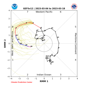
It is fascinating to watch the models try to handle the Tropical Forcing provided by the Madden Julian Oscillation. (MJO) There not doing a great job. The MJO is now in later phase 7, (see Below) approaching, then crossing into Phase 8.
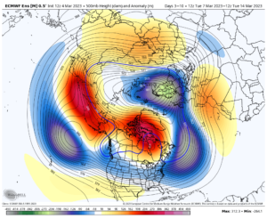
More often then not, we get AR`s when this happens. So odds are good, that no matter what the models are doing, odds of a significant AR will affect the west coast of the US somewhere. At the moment, the key here is where the upper blocking high is going to set up. For a fetch into California, it should be more over South Central and Eastern Alaska. It’s more over or west of the dateline in many model run forecasts, which has the tendency to force higher heights, (High Pressure Aloft) over our state…..South to North
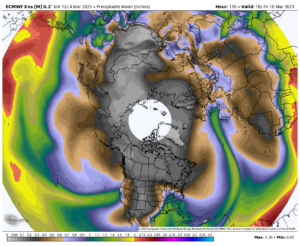
With the MJO forecasted to be east into Phase 8 later next week, we will know one way or another our chances for an MJO forced AR into CA by Mid Week next week or sooner. I will post the new ECMWF at about Noon. It appears that the Euro which was dry the last few days is Wet for CA Now and the GFS has gone dry. So we need more time until they sync up, one way or another. Look below and see how wet the Euro has gone. It does not mean a thing until there is consensus with the GFS.
In the meantime, get ready for more deep powder by late Sunday. (Snorkel’s Required!)
___________________________________________________________________________________________________________________________________________________________________________
3-3-2023
Another Winter Storm is on the way beginning Saturday afternoon….This storm will be in the strong-moderate category. 12 to 20 inches in town and 2 foot plus on Mammoth Mt by Monday AM. Sunday looks like the stormiest day with the heaviest snowfall. The Upper low stalls off the Oregon coast for a few days. The first system in the long wave trough kicks in Late Monday night, with another impulse moving down through CA Wednesday night. The current forecast keeps the Owens Valley dry much of next week. However model trends this AM suggest that the Owens Valley will get at least some rain or snow by Wednesday afternoon or night as the core of the 2nd impulse drives down the San Joaquin Valley Wednesday Night. Some additional light snowfall is likely in the high country as well Wednesday and Wednesday night from this system. One last impulse Thursday will kick the mess out with just a cold day Thursday with a little upslope snow possible.
Expect improving weather next Friday.
At this time, the Dweebs are holding off on the following weekends outlook. There are just too many differences in the models for serious confidence in the AR possibilities. It could go either way at this point.
Stay Tuned….


