Brought to you by Howard Sheckter
Mammoth Weather Outlook
Winter Storm Warning in Effect….Expiring at 10:00PM Tonight……White Out Conditions now in town with Gusts to 30MPH…..Snowfall will taper off later today……Tuesday will be dry……Light Snowfall expected Wednesday night and Thursday AM then dry Friday Saturday Sunday…
Monday January 16, 2023
Surface Low crossed the Sierra this morning and is located about Hawthorne, Nevada. Nice deformation zone set up between Hawthorne, NV and up into Reno providing snowfall over Western NV and the Eastern Slopes of the Sierra. SW flow has increased in Mammoth with whiteout conditions at this time. Please do not drive under these conditions… Please check with Caltrans before traveling north or south on Highway 395. Mammoth Mt shows over 4 feet storm total over the past few days….Up to another foot is possible today…. Platinum Powder Alert for Tuesday from todays storm with one foot or better on the slope at 15:1 (Platinum Powder)…
Weather Discussion:
Latest Model Simulations show Snowfall rapidly tapering off after mid afternoon and will end by early evening. After the break in the snowfall later today, It will be quite cold Tuesday with diminishing clouds then clearing over night Tuesday night. Low temps will will go -17F to -6F throughout Mono County early Wednesday morning and although the Blue Birds are gone, it will be that kind of day!. Cold Dry Powder a sure bet with EGO snow! Make sure you have the right wax for the very cold snow in the morning…
Another weaker system will bring some 1 to 5 inches Wednesday night into Thursday AM with high snow to water ratios. That will be the last storm in this cycle. Temps will remain cold for the rest of the week with some moderation over the weekend. 20s for highs.
Looking at next weeks weather….Over all great! There is a cold system that drops out of BC, Canada bringing very cold air and NE wind over the Sierra Crest Monday the 23rd. Its to soon to see if we get any meaningful upslopes from it but it is not expected to bring any substantial snow…..Mainly snow showers Monday. Today’s model simulations show the wind with this pattern at 700MB (10,000 feet) is strongest over the Northern Sierra. The system spends time over Tonopah, NV, during early morning hours Monday…..Best chance for upslope.
Thereafter, there will be some windy periods week two but northing unusual and it looks like precipitation will be below normal.
Tropical Forcing:
There are a few very interesting developments the last week of this month.
The first strong MJO; Madden Julian Oscillation is expected to affect the mid latitude flow toward the end of the month. Retrogression is being shown in the global models the last week of the month of January. Another storm cycle is now a good possibility as the MJO is forecasted to be very strong in the RMM Phase 3. Composites show wet weather for CA in January and February for that phase.
Although a new long wave Trough is expected to carve out over the far Eastern Pacific toward months end, we do not know if this pattern will set up with AR’s again. However, today extended model 12z GFS simulations for early February shows that; so there is some possibility although that pretty far out in time. Therefore please consider your snowpack around your home and or businesses and diminish the loading on your roofs. Do this before the end of the month!! The last series of ARs were not really warm AR’s. They were not the Colloquial Pineapple Connection as the moisture was mainly subtropical. Should an intense static AR develop from Hawaii, with freezing levels well above 10,000 feet, that could be disastrously. While there is no forecast for that that at this time, it is still a good idea to have roofs shoveled in the meantime.
See one possibility below:
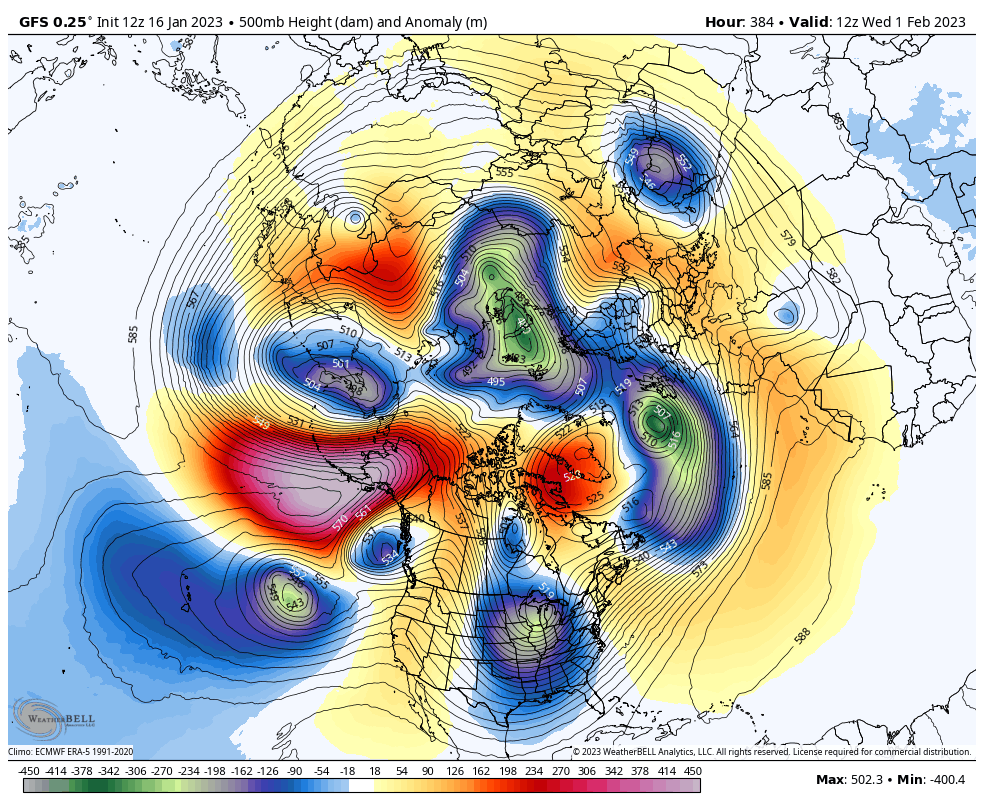
I also wanted to add that there is a very strong Strato-Warming event taking place over the Arctic in a few weeks. See graphic Below. That will most likely have an affect on our Northern Hemispheric Pattern. However, it is unknown to what change it will bring.

Stay in touch with Mammoth’s best weather site!! Reporting the Weather in Mammoth for the media for over 40 years!
Dr Howard and the Dweebs…………………:-)


