Mammoth Weather
Brought to you by Howard Sheckter
Brought to you by Howard Sheckter
The forecast and outlook are still pretty much straight forward this upcoming week with the dry weather trend holding with strong temperature inversions, due to the persistent west coast ridge. This ridge will actually strengthen Tuesday through Thursday with the freezing level topping out at about 14,000 feet by Thursday afternoon.. Thereafter, a passing short wave Friday night will flatten the ridge somewhat, bringing some breeze over the upper elevations and some cooling aloft. It may be enough to mix out the valleys by early Saturday AM…well see. Temperatures this week in Mammoth will rise to the mid 50s with lows in the upper 20s to possibly low 30s in the upper elevations of town by Thursday morning. Some cooling is expected over the weekend. Lows at night have been running about 10 degrees cooler in town than at the Village. So 15 to 25 degrees as of late. These lows will come up a bit by Mid-Week.
There really is not anything in the models that look striking different from what has been said of late. Those that follow the 21 day cycle of pattern change might be interested in knowing that this current pattern began on the 5th of December as indicated by reanalysis 500mb charts. 21 days would put the next pattern change or “transition” about Christmas. This does not mean that we will not see any moisture until then, as within this pattern we could still get something that sneaks in here bringing something light. It just means that a meaningfull transition is not expected based upon this theory until about Christmas. Furthermore, with that said, it is not really known what we are going to transition to.
Optimism:
Let me chat about Sea Surface Temps.
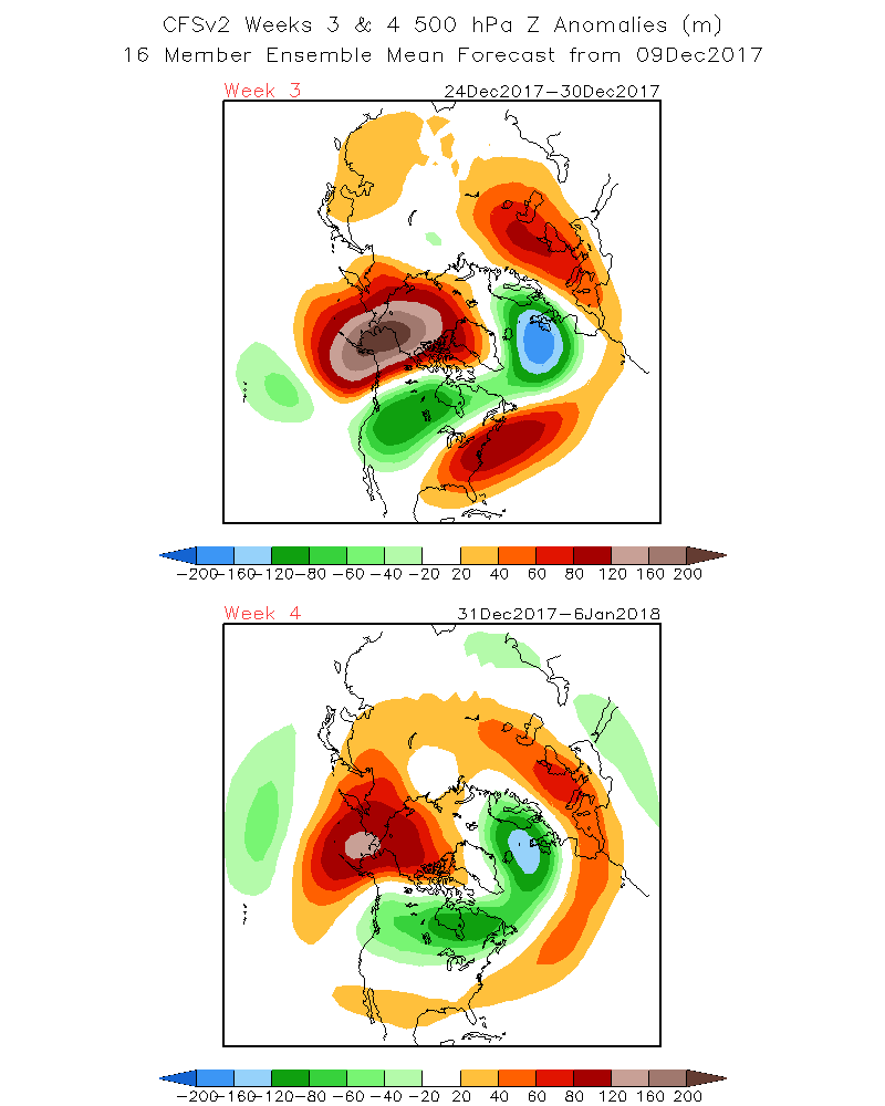
What I like out over the pacific is the increasingly warm pool in the Bering Sea. Whether it’s the Chicken or the Egg, these anomalous warm Sea Surface Temperatures often times attract large-scale high pressure systems in their vicinity during this time of the year. This may cause the current long wave pattern to retrograde with a good solid block developing in the WPO region either later this month or most likely in January. If/when this happens it could get quite wet in California. The warmest positive sea surface anomalies are currently in the Bering Sea and south of there. On the negative side, SSTAs along the California coast are getting pretty warm as well. This may tend to keep Southern CA drier, I do not know. The CPC Climate models are showing 500MB Heights retrograding to this area during the Weeks 3 and 4 period. See Graphics below.
Based upon the 21 day cycle, were probably going to have to get through the next two weeks being dry, as today is only day 5 of that period. However, if the Climate Models are correct from the CPC, showing a block developing in the southern part of the Bering Sea -(WPO); Beginning the week following Christmas and Week 4 “New years Eve through Jan 6th”. We could get some badly needed precipitation. Week 3 looks cold temperature wise, with week four looking more moderate in temperature as there is more over water trajectory with the upper jet. . On another note, other graphics which I am not authorized to display from another model is trending wetter as well for the northern half of California in January. I hope they all verify!
Think Snow!!!!
